
The Weather Network’s Summer 2022 Forecast
The most anticipated season of the year is finally here! After a sluggish spring which tested our patience, will summer be more favourable for enjoying our favourite outdoor activities? Or will a stormy pattern impact summer plans? To answer these questions, The Weather Network has released its summer forecast with an overview of what Canadians can expect for the months of June, July, and August.
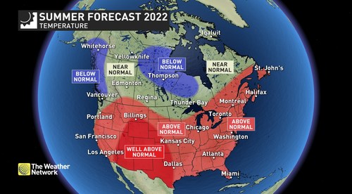
“This summer will feature widespread warm weather, as most of Canada will see normal or above normal temperatures,” said Chris Scott, Chief Meteorologist at The Weather Network. “However, the heat and humidity combined with an active jet stream pattern will contribute to a stormy summer at times across much of the country. While thunderstorms will interrupt our plans from time to time, they will also usher in a few periods of cooler weather to provide relief from the heat. Thankfully, widespread drought, wildfires and smoke are less of a concern for this summer than they have been during many recent years.”
Below is a more detailed look at the conditions that we expect across Canada this summer:
Ontario & Quebec – A very warm and humid summer is expected across most of the region, but a cooler summer is forecast across parts of northwestern Ontario. A few heat waves are likely across southern Ontario and Quebec, but periods of cooler weather will provide temporary relief. Due to the heat and humidity and several cold fronts, we expect stormy weather at times. These storms will produce a wide range in rainfall totals, with many areas seeing above normal precipitation, while some places could frequently miss out. However, overall we expect a favourable season for agriculture and numerous warm and sunny days for enjoying outdoor activities.
The Prairies – This summer will not be as hot and dry at last summer. However, the agricultural season is off to a very difficult start due to flooding across eastern parts of the region and drought conditions across southwestern areas. We are cautiously optimistic that conditions will improve for agriculture as the season progresses, but for some areas it could be too little too late. An active storm track is expected across a large part of the region, but southwestern areas are at risk to frequently miss out on the much needed rain.
British Columbia – After a sluggish spring, the cool and unsettled pattern is expected to continue well into June. Periods of hot and dry weather are still expected during July and August with a risk for wildfires. However, we do not expect that heat, drought and smoke will dominate the season as they did last year, or have during many summers in recent memory.
Atlantic Canada – A warm and humid summer is forecast, but occasional cold fronts will bring stormy weather at times and a break from the muggy conditions. Above normal precipitation is expected across the Maritimes, as we anticipate that a few moisture-laden systems will account for a large percentage of the rainfall totals for the season. We are also closely watching the tropics as a very active hurricane season is expected with a heightened risk for tropical systems to impact Atlantic Canada.
Northern Canada – Near normal or cooler than normal temperatures are expected across most of the region with the coolest weather relative to normal across southern Nunavut and southern Yukon. Near normal to above normal precipitation is expected across the region with the wettest weather around northern parts of Hudson Bay. As a result, we should have a reduced risk for wildfire smoke across the region.
We are dedicated to delivering you the most in-depth forecasts to help you plan your daily activities. Get your daily forecast and be prepared for changeable weather by visiting www.theweathernetwork.com or by downloading The Weather Network App and creating an account for personalized and up-to-the minute forecasts.
|
The Weather Network: Summer 2022 Forecast |
||
|
Region |
Temperature Outlook |
Precipitation Outlook |
|
British Columbia |
Near Normal interior |
Above Normal coastline; Near Normal |
|
Alberta |
Near Normal, but Above Normal |
Above Normal northcentral; Near |
|
Saskatchewan |
Near Normal but Above Normal |
Near Normal south and north; |
|
Manitoba |
Near Normal south; Below Normal |
Near Normal southwest and far |
|
Ontario |
Above Normal south; Near Normal |
Above Normal; Near Normal |
|
Québec |
Above Normal south and east; |
Above Normal south and far |
|
The Maritimes and Newfoundland and Labrador |
Above Normal; Near Normal |
Above Normal New Brunswick |
|
Yukon, Northwest Territories, Nunavut |
Below Normal southern Yukon, |
Above Normal near northern |
Complete Summer Forecast details, including regional breakdowns, maps, and charts are available at www.theweathernetwork.com/summer.


