
Concerned residents in the Township of Muskoka Lakes are taking to social media to raise alarming awareness for high water levels.
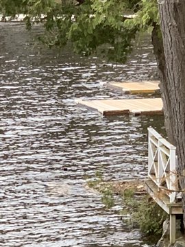
“Clearly the current levels are too high for general infrastructure (docks/ boathouses) and with no major snow this winter, not a lot of rain and a regular spring melt, this year provides clear indication that the plan (MRWMP) is broken.” says Muskoka Lakes Mayor Phil Harding
The province has issued a press release:
The Ontario government has been actively working with federal and municipal governments, First Nations partners, and non-governmental organizations to prepare and respond to any flooding situation across the province during the COVID-19 outbreak.
As part of Ontario’s flood preparedness planning, the province has been working with the federal government, municipalities and First Nations partners to develop evacuation plans. Recognizing the impact of COVID-19 on municipalities this year, Ontario is taking the lead on identifying suitable locations to host evacuees and to minimize the reliance on municipal resources for various supports, including health care and social services.
As a result, the province has taken steps to ensure that provincial, federal and non-governmental resources, such as the Canadian Red Cross, can be deployed to minimize the burden on local communities as much as possible.
The flooding update was provided today by Premier Doug Ford, John Yakabuski, Minister of Natural Resources and Forestry, Sylvia Jones, Solicitor General, and Christine Elliott, Deputy Premier and Minister of Health.
“During these unprecedented times, our government is prepared for any scenario, and that includes the spring flooding season,” said Premier Ford. “By working together with our federal, municipal, and First Nations partners and putting our provincial flooding strategy into action, we have taken the critical steps needed to help keep people and communities safe.”
Ontario has also been engaging with the federal government to support First Nations communities staying on their lands as long as it is safe to do so, including where First Nations community members would be temporarily relocated to higher and safer grounds within their own communities. Relocating community members from reserve to traditional hunt camps or other remote sites also addresses concerns around the potential spread of COVID-19 to these vulnerable communities.
“Our staff are closely monitoring ongoing flooding risks across the province and working with partners and communities on any areas of concern,” said Minister Yakabuski. “We are ready to respond to any requests for sandbags during this very challenging time. We also continue to work with our partners to advance the important long-term initiatives outlined in Ontario’s Flooding Strategy, which will help us become more resilient to flooding events in the years to come.”
Current provincial projections show a moderate-to-high risk of flooding for northern Ontario and the James and Hudson Bay coasts, where staff are closely monitoring all major tributaries in anticipation of ice breakup, expected to begin in early May. As of April 30, 2020, surveillance flights have begun across the Far North to monitor these ice breakups, with operations based out of the Ministry of Natural Resources and Forestry’s Moosonee Field Office.
There is also a risk of shoreline flooding from snow melt in southern Ontario along the Great Lakes. The province’s Surface Water Monitoring Centre in Peterborough continues to monitor water levels in other areas at risk throughout the province, including communities in the Ottawa Valley and along the Great Lakes.
“Thanks to the extraordinary efforts of our emergency management personnel and partners, we will be able to safely evacuate Northern communities and provide for their needs until they can safely return home,” said Solicitor General Jones. “We continue to monitor flood risks and we are assessing all necessary actions to maintain the safety and wellbeing of communities. We will be ready to proceed with evacuations should the need arise.”
“Our government will continue to work with First Nations leadership and the federal government to ensure the safety of remote Indigenous community members during the flood season,” said Greg Rickford, Minister of Indigenous Affairs. “If or when an evacuation occurs, it will be conducted in the safest way possible, providing additional support to evacuees and northern host communities. Indigenous leaders across the province have taken critical steps to protect their communities from the spread of COVID-19 and we will continue to support those efforts through out the flooding season.”
In March, the government released Protecting People and Property: Ontario’s Flooding Strategy, which outlines the steps the province is taking to reduce flood risks and help Ontarians better prepare for flooding events. Actions outlined in the strategy include increasing access to current and timely information, using improved future rainfall prediction data and establishing a flood mapping technical team.
Quick Facts
- Ontario works to keep people safe and secure by coordinating with other organizations to prepare for and respond to emergencies. In parallel to the work done to prepare for potential flood-related evacuations, the province is also engaged in a contingency planning process to prepare for the forest fire season.
- To determine the potential for flooding, Ontario monitors flood risks on a continuous basis. This includes using weather forecasts, recorded snow depths, and stream gauge and camera data to analyze water levels and flows.
- For remote far northern areas of Ontario, the province uses radar and satellite imagery, surveillance flights and Indigenous community knowledge and expertise.
- Ontario’s Surface Water Monitoring Centre carries out storm surge modelling and provides twice daily notifications to local conservation authorities and the Ministry of Natural Resources and Forestry’s district offices along the Great Lakes.
- Great Lakes water levels remain very high — particularly Lakes Erie, Huron, St. Clair and Superior — and this is expected to continue for the next few months. The municipalities of Chatham-Kent and Pelee both declared emergencies this year due to high levels and storm surge impacts on Lake Erie.
- In 2019-20, as part of a $1-million “Build Back Better” pilot project, the province provided municipalities that qualified for Municipal Disaster Recovery Assistance funding with up to 15 per cent above the estimated cost of rebuilding damaged public infrastructure to make it more resilient to extreme weather. Eligible projects include raising roads to provide better overland flow of water, improving bridges, and increasing the size of ditches and catch basins to increase their capacity to hold water.
- The province’s updated Provincial Policy Statement (PPS), which came into effect May 1, responds to the recommendations of the report of the Special Advisor on Flooding and is part of Ontario’s Flooding Strategy. The PPS, 2020 acknowledges the role of the province, planning authorities and conservation authorities in working together to mitigate the risks associated with natural hazards, including the impacts of a changing climate.
- As part of Ontario’s Action Plan: Responding to COVID 19, the government committed $4.3 million to support emergency planning and management in remote First Nations in the event that these First Nations are forced to evacuate during the COVID-19 pandemic.


