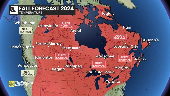
All of Canada has experienced an early taste of fall weather, but summer has made a strong comeback across much of the country. Is this summer’s grand finale, or will warm weather linger well into the fall season?
To help answer this question, The Weather Network has released their fall forecast.
“The transition to consistent autumnal weather will be slower than what we typically see across most of Canada,” said Chris Scott, Chief Meteorologist at The Weather Network. “Extended periods of pleasant fall weather are expected to last well into October, especially across the eastern half of the country. However, we are closely watching the potential for an abrupt transition to a colder pattern before the end of the fall season.”
Keep in mind that changeable weather is the trademark of the fall season and this year will be no exception. However, throughout this temperature roller coaster, the periods of warmer than normal temperatures are expected to be more dominant than the shots of colder weather for areas east of the Rockies. Meanwhile, for B.C. and the Yukon, the alternating periods of warm and cold weather should come close to offsetting each other.
An active pattern along our Pacific coast is expected to deliver above normal precipitation totals to southern B.C. Otherwise, we expect that the rest of Canada will experience fewer than normal fall storms through October. However, the storms that do occur could still pack quite a punch and both coasts will have a heightened risk of excessive rain events. A stormier pattern is expected to develop across Canada as we transition into early winter.
Here’s a more detailed look at the conditions that we expect across Canada this fall:
British Columbia
Near normal temperatures are expected as changeable temperature patterns should come close to offsetting each other. However, the B.C. Peace region and the Rockies should tip to the mild side of seasonal. An active pattern into the south coast region in combination with warmer than normal ocean water temperatures in the north Pacific should deliver above normal precipitation totals to southern parts of the province, along with a risk of an excessive rainfall event. However, this pattern should also support a much stronger start to the ski season than last year.
The Prairies
Warmer than normal temperatures are expected to dominate through most of the fall season, but there will still be periods of colder weather, especially across Alberta during October. Near normal precipitation is expected, though parts of southern Alberta could end up with above normal totals, while eastern Manitoba is at risk of below-normal precipitation. An abrupt transition to early winter is expected, but the timing remains uncertain.
Ontario & Quebec
Warmer than normal temperatures are expected to dominate through October with extended periods of pleasant weather. However, the mild pattern is expected to break down before we reach the end of the season. Fewer than normal fall storms are expected through October, but we will have a heightened risk of a couple of powerful storms which could pack quite a punch.
Atlantic Canada
Warmer than normal temperatures are expected to dominate for much of the region, especially through October. Precipitation totals are expected to be near normal across much of the region, but southern areas have the potential to be wetter than normal due to the risk of excessive rain events from tropical systems. While the hurricane season has turned rather quiet, we will continue to keep a close eye on the tropics as an active end to the season is still expected.
Northern Canada
Warmer than normal temperatures are expected to dominate across most of the region, but near normal temperatures are expected across the Yukon and into western parts of the Northwest Territories. Near normal or above normal precipitation is expected across the region. Above normal totals are most likely across much of the NWT and into western Nunavut.
Keep in mind that even a mild fall can bring dangerous winter weather conditions to parts of Canada with little notice. As we move deeper into the season, Canadians should pay extra close attention to the daily forecast as winter weather conditions can develop and change rapidly.
Complete Fall Forecast details, including regional breakdowns, maps and charts are available on our seasonal page at theweathernetwork.com/fall.
|
The Weather Network: Fall 2024 Forecast |
||
|
Region |
Temperature Outlook |
Precipitation Outlook |
|
British Columbia |
Near normal; Above normal east |
Above normal south; Near normal |
|
Alberta |
Above normal |
Near normal; Above normal far |
|
Saskatchewan |
Above normal |
Near normal |
|
Manitoba |
Above normal |
Near normal; Below normal east |
|
Ontario |
Above normal |
Near normal; Below normal |
|
Québec |
Above normal |
Near normal |
|
The Maritimes and |
Above normal |
Above normal south; Near normal |
|
Yukon, Northwest |
Above normal; Near normal Yukon |
Above normal most of NWT and |
Canadians can prepare for changeable weather by visiting theweathernetwork.com or by downloading The Weather Network App, available on iOS and Android, and creating an account for personalized and up-to-the-minute forecasts.


