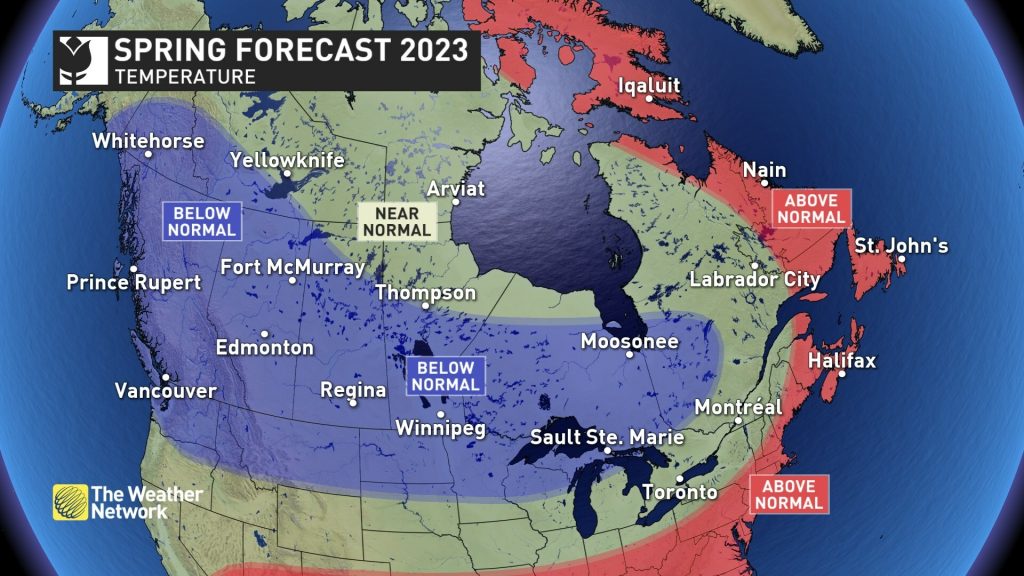
Spring-like weather arrived early this year across most of Canada with extended thaws and even times of record-breaking warmth during the heart of winter. Was spring just teasing us, or can we anticipate consistent warm weather that will arrive early this year?
According to The Weather Network’s Spring Forecast for the months of March, April and May, most Canadians will need to be patient as we wait for consistent warm weather.
“Winter lacked commitment this year as episodes of severe winter weather were followed by extended periods of early spring-like weather” said Chris Scott, Chief Meteorologist with The Weather Network. “However, it appears that winter will attempt to make up for lost time during March and even into April. Several more rounds of wintry weather are expected across the country before spring finally hits its stride.”
The sluggish start to spring should result in most of Canada seeing temperatures that are near normal or on the cold side of normal for the season. An active storm track should bring near to above normal precipitation for most of the country.
Below is a more detailed look at the conditions expected across Canada this spring:
Ontario & Quebec – Extended periods of early spring-like weather during the heart of winter provided false hope that spring was going to arrive early. March and even parts of April will feature several bouts of winter weather with periods of colder than normal temperatures and messy winter storms. An active storm track and a few moisture laden systems are expected to bring above normal precipitation to the region for the season. However, we are watching the potential for a strong ending to the season with warmer and drier weather.
British Columbia – A slower than typical start to spring is expected with below normal temperatures, especially during the first half of the season. Cooler weather and slightly above normal precipitation should allow for an extended spring ski season. These conditions should also reduce the risk for an early start to the fire season and help to replenish reservoirs before we head into summer.
The Prairies – A slow start to spring is expected with colder than normal temperatures, especially during the first half of the season. March, and even April, could look and feel wintrier than what we saw during the heart of winter. Near normal precipitation is expected across most of the region, but southwestern Alberta has the potential to see above normal precipitation totals.
Atlantic Canada – Very mild weather dominated through most of the winter, but a colder pattern during March and April, along with an active storm track, should bring a strong ending to a lackluster season. This includes a heightened risk for late season winter storms. However, spring should make a solid recovery during the second half of the season with temperatures ending up warmer than normal across most of the region.
Northern Canada – Colder than normal spring temperatures are expected across southern parts of the Yukon and southwestern parts of the NWT. Meanwhile, a strong blocking pattern over Greenland and Baffin Island should bring above normal temperatures to northeastern parts of Nunavut. Near normal temperatures are expected elsewhere, but a cold start to the season is expected around Hudson Bay as the polar vortex is expected to linger over this region. Near normal precipitation is expected across most of the region.
Over the next few weeks, Canadians should pay close attention to the daily forecasts as weather and road conditions can change rapidly by visiting the www.theweathernetwork.com or by downloading The Weather Network App available on iOS and Android and creating an account for personalized and up-to-the minute forecasts.
|
The Weather Network: Spring 2023 Forecast |
||
|
Region |
Temperature Outlook |
Precipitation Outlook |
|
British Columbia |
Below normal |
Above normal south; Near |
|
Alberta |
Below normal |
Near normal; Above normal |
|
Saskatchewan |
Below normal; Near normal far |
Near normal |
|
Manitoba |
Below normal; Near normal far |
Near normal |
|
Ontario |
Near normal south; Below normal |
Above normal south; Near |
|
Québec |
Near normal south; Below normal |
Above normal south; Near |
|
The Maritimes and |
Above normal; Near normal for |
Above normal Maritimes & |
|
Yukon, Northwest |
Below normal southern Yukon and |
Near normal: Below normal for |
Complete Spring Forecast details, including regional breakdowns, maps and charts are available at www.theweathernetwork.com/spring.
Interview opportunities: The Weather Network meteorologists are available for interviews to provide additional details and localized insights about this year’s Spring Forecast.
