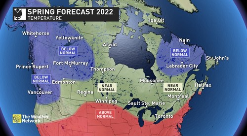
An early taste of spring has already been enjoyed by most Canadians as February featured brief periods of very mild and even record-breaking temperatures. Will warmer weather continue to tease during the weeks ahead, or is spring ready to commit to an early start across Canada?
According to The Weather Network’s Spring Forecast for the months of March, April and May, most Canadians will need to be patient as we wait for consistent warm weather.
“Spring is known for its changeable weather, but this year looks especially tumultuous,” said Chris Scott, Chief Meteorologist with The Weather Network. “Periods of warm spring weather will be a delightful contrast to winter’s fury which we’ve all experienced at times during the past three months. However, this will be a case of two steps forward and one step back, as we’ll see several more bouts of winter-like weather before spring finally hits its stride across the country.”
The volatile temperature pattern should result in most of Canada seeing temperatures that are near normal or on the cold side of normal for the season. An active storm track should bring near to above normal precipitation for most of the country.
Below is a more detailed look at the conditions expected across Canada this spring:
Ontario & Quebec – Early tastes of warm spring weather will continue to tease at times, and this region can look forward to periods of very warm weather as the season progresses. However, spring will also test our patience with a few significant setbacks expected as well. An active storm track and a few moisture-laden systems are expected to bring above normal precipitation to the region.
British Columbia – A slower than typical start to the season is expected with below normal temperatures. This should allow for outstanding spring skiing with a good snowpack already in place and additional alpine snow expected. A cooler spring, along with above normal precipitation, should greatly reduce the risk for an early start to the fire season.
The Prairies – A heightened potential for turbulent temperatures is expected across this region. Near normal precipitation totals are expected for most areas, but we will closely monitor southern Alberta where soil moisture is currently well below normal with the approach of another growing season. Above normal snowpack will contribute to a risk for spring flooding across southern Manitoba.
Atlantic Canada – After a mild winter, this region will settle into a more typical spring pattern with back-and-forth temperature swings that come close to offsetting each other. An active storm track and moisture-laden systems should bring above normal precipitation across the region and a heightened risk for late season winter storms.
Northern Canada – Colder than normal spring temperatures are expected across the Yukon and NWT, while near normal temperatures are expected across Nunavut. Near normal precipitation is expected across most of the region.
Over the next few weeks, Canadians should pay close attention to the daily forecasts as weather and road conditions can change rapidly by visiting the www.theweathernetwork.com or by downloading The Weather Network App available on iOS and Android and creating an account for personalized and up-to-the minute forecasts.
|
The Weather Network: Spring 2022 Forecast |
||
|
Region |
Temperature Outlook |
Precipitation Outlook |
|
British Columbia |
Below normal |
Above normal south and central; Near normal north |
|
Alberta |
Below normal north, central, and west; Near normal south |
Near normal |
|
Saskatchewan |
Below normal north and central; Near normal south |
Near normal |
|
Manitoba |
Near normal |
Near normal; Above normal far east |
|
Ontario |
Near normal |
Above normal |
|
Québec |
Near normal; Below normal northeast |
Above normal south; Near normal central and north |
|
The Maritimes and Newfoundland |
Near normal; Above normal southwest Nova Scotia |
Above normal |
|
Yukon, Northwest Territories, Nunavut |
Below normal Yukon and NWT; Near normal Nunavut |
Near normal |
Complete Spring Forecast details, including regional breakdowns, maps and charts are available at www.theweathernetwork.com/spring.
