Summer finished strong across most of Canada as very warm and dry weather dominated during August and into the first part of September. Is this a sign of what is to come for the fall season, or is winter poised for an early arrival?
To help answer this question, The Weather Network has released their fall forecast.
“Most Canadians are enjoying an extended summer season with dry weather and mid-summer-like temperatures continuing deep into September,” said Chris Scott, Chief Meteorologist at The Weather Network. “Extended periods of pleasant fall weather are expected to last through much of October across most of the country. However, a much wetter and stormier pattern is expected to develop for mid & late fall for B.C., and we are closely watching the tropics and the risk for storms to impact Atlantic Canada.”
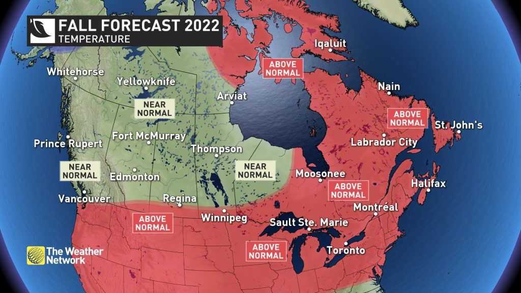
Nearly all of Canada can expect near or above normal temperatures for the fall season as a whole. However, that doesn’t mean that we will just coast all the way through to the winter months with mild temperatures. During November we should see periods of more typical late fall weather, which will include snow for many Canadians.
Much of the country will experience fewer fall storms than what we typically see. However, the storms that do occur could still pack quite a punch and both coasts have a heightened risk for excessive rain events.
Here’s a more detailed look at the conditions that we expect across Canada this fall:
A very warm and dry start to the season will result in a heightened risk for wildfires continuing later into fall than normal. However, a much wetter pattern is expected to develop mid and late season. A typical number of fall storms and rainy days are expected, but this should result in above normal precipitation totals as moisture laden systems will bring the risk for excessive rainfall at times. Near normal temperatures for the end of the season should allow the ski season to start on time.
Warmer than normal temperatures are expected across southern parts of the region, especially during the first half of the season. Later in the season we expect a more typical pattern to develop which will include changeable temperatures and a few tastes of early winter-like weather.
Warmer than normal temperatures are expected to dominate most of the fall season with extended periods of pleasant weather through October. However, the milder pattern could break down before we get to the end of the season. We also expect fewer fall storms than what we typically see, but a few storms could still pack quite a punch with heavy rain.
Warmer than normal temperatures are expected to dominate the fall season, and that will include periods of dry weather that will be ideal for enjoying the fall foliage. However, the hurricane season is expected to become very active for the second half of the season, so we will continue to keep an eye on the tropics and the potential for a few systems that could bring heavy rainfall totals to parts of the region.
Warmer than normal temperatures and above normal precipitation totals are expected across eastern Nunavut, including Iqaluit. Elsewhere across the region, near normal temperatures and precipitation are expected.
Keep in mind that even a mild fall can bring dangerous winter weather conditions to parts of Canada with little notice. As we move deeper into the season, Canadians should pay extra close attention to the daily forecast as winter weather conditions can develop and change rapidly. Canadians can be prepared for changeable weather by visiting www.theweathernetwork.com or by downloading The Weather Network App and creating an account for personalized and up to the minute forecasts.
|
The Weather Network: Fall 2022 Forecast |
||
|
Region |
Temperature Outlook |
Precipitation Outlook |
|
British Columbia
|
Near normal |
Above Normal |
|
Alberta
|
Near normal; Above normal south
|
Near normal |
|
Saskatchewan |
Near normal; Above normal south
|
Near normal |
|
Manitoba
|
Near normal; Above normal south |
Near normal; Below normal east central
|
|
Ontario |
Above normal; Near normal northwest
|
Near normal; Below normal parts of north |
|
Québec |
Above normal |
Above normal south and parts of east and north; Below normal west central; Near normal central |
|
The Maritimes and Newfoundland and Labrador |
Above normal
|
Above normal |
|
Yukon, Northwest Territories, Nunavut |
Above normal eastern Nunavut; Below normal west central Yukon; Near normal elsewhere |
Above normal eastern Nunavut; Near normal elsewhere |
Complete Fall Forecast details, including regional breakdowns, maps, and charts are available at www.theweathernetwork.com/fall.
